Biological Risk Assessment Tool
In the framework of the Atlantic BluePorts project, Bentley Systems has developed a risk assessment tool to help risk experts, national authorities, seaport administrators and ship owners perform risk assessment studies analyzing and supporting ballast water management in European ports.
The tool makes use of the concept of Same Risk Area, an area-based approach that considers the extent of natural dispersion of aquatic invasive species potentially present in ballast water. It identifies the natural connectivity of species-of-concern due to natural hydrodynamic dispersion within a wider area and it can be used by administrations as a decision-support tool to grant area-based exemptions to ships trading in short sea shipping.
The tool is based on a Lagrangian (particle tracking) model capable of simulating the natural dispersion of the target species transported by sea currents that have been calculated by validated hydrodynamic models (e.g. CMEMS - EU Copernicus Marine Environment Monitoring Service).
A pilot risk assessment study was carried out covering a group of relevant seaports located in the Atlantic Area, most of which are partners in this project, namely: Lisbon, Sines and Funchal (Portugal), Las Palmas, Algeciras, Sevilla, Vigo and Gijon (Spain), Brest(France), Liverpool (UK), Cork (Ireland) and Rotterdam (The Netherlands).
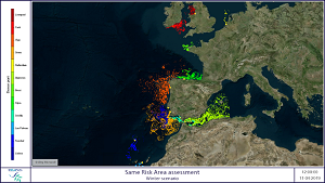
Two meteo-oceanographic scenarios were designed representing winter and summer conditions and using2019 CMEMS - IBI model data.
Both scenarios represent a period of 3 months, where based on the sea currents, the model calculates the transport and trajectory of Lagrangian particles continuously emitted from each donor port. The particles represent potential invasive species during their larval stage. Thus the simulation period takes into account the 3 months representing the seasonal meteo-oceanographic conditions plus the duration of the larval period.
The risk assessment tool then processes the results and calculates an aggregated cumulative density of particles in the study area during the period of the simulation and verifies if particles emitted from a donor port arrive (naturally transported by sea currents) in the vicinity of the other ports. If they dont arrive, then there is low natural connectivity (between the 2 ports, for that species and season). In this case, the represented species is potentially invasive if present in untreated ballast water in a ship traveling from the donor port to the receiving port. On the other hand, if the natural connectivity is high, this means that theres a high probability that the species is already present in the donor and receiving port due to natural transport processes and thus cannot be seen as an invasive species.
The risk assessment tool and modeling methodology is therefore important for helping regulators to have the necessary information not only to determine exemptions in ballast water treatment in ports with high connectivity index but to especially to identify and justify treatment in low connectivity ports.
 Send this story to a colleague